The change in weather has been dramatic since leaving the Equator. Almost overnight, we went from wearing shorts and t-shirts to wrapping up in scarves and gloves! The temperature rapidly plummeted from >30°C degrees in mid November to 5°C by the end of the month. At 54° South of the Equator, we arrived at our first stop, the beautiful oasis of South Georgia. South Georgia and a collective chain of islands, the South Sandwich Islands, are British Overseas Territory and are uninhabited except from the government officers and people living and working at the British Antarctic's research stations. These islands are located in the South Atlantic Ocean and experience the Antarctic Convergence- a major transition zone in the ocean which separates Antarctic and sub-Antarctic water. The convergence curve continuously encircles Antarctica and varies in latitude seasonally. When we hit 49° S, the temperature dropped 10°C in 24 hours. The zone of convergence forms a significant biological boundary where the cold, dense surface waters of the circumpolar ocean sinks and flows northwards bringing to the surface nutrient rich water. As a consequence, the islands are incredibly productive and host a formidable array and abundance of wildlife.
The first base we stopped at was King Edward Point (KEP)- a hub for fisheries research.

Arrival to South Georgia with view on King Edward Point's research station
A key purpose of the JCR's journey is to re-supply BAS's stations with cargo from food and drinks to scientific equipment. The JCR was able to come alongside at Kind Edwards Point due to its sturdy jetty. Therefore, cargo relief was complete within a few hours using cranes to offload shipment containers directly onto the runway. During this 48 hour stop off, we were free to roam the island...
Day one consisted of visiting the largest whaling station on South Georgia, Grytvicken. The station was founded by a Norwegian but the settlement was named by a Swedish archaeologist and the name translates to 'the Pot Bay'. It was an eerie site to walk around seeing whale harpoons, saws and huge machinery that inflicted so much decimation. You could imagine whales (such as the largest blue whale ever recorded at 33.6m ) being winched onto the ramp for subsequent processing. I was amazed to see that drums of whale oil remain standing. The station closed in 1966 when dwindling whale stocks made it commercially unviable. In the foreground of the photo below, you may be able to make out the 'whalers' church which was built on Christmas day in 1913. The church built by whalers, hosted Ernest Shackleton's funeral service and whalers lost at sea. It is one of the most southern churches on Earth.
Walking around an old whaling station- Grytvicken

The JCR with a backdrop of Grytvicken
During Shackleton's Trans-Antarctic expedition from 1914-17, pack ice in the Weddell Sea sunk the research vessel Endurance holding 27 men. A lifeboat, the James Caird, was used by Shackleton and his men to travel 1,300 km from Elephant Island (Shetland Islands) through the Southern Ocean to reach South Georgia! Such a journey has gone down in history as one of the greatest small-boat journeys ever completed with only a broken watch and sextant for navigation. Shackleton returned to South Georgia in 1921 where he died of a heart attack whilst at anchor in South Georgia- his wife requested that he was buried there. Before leaving the UK I read 'South: The Race to the Pole' and saw a photo of Shackleton's enormous grave stone at South Georgia. Witnessing it in the flesh was quite something.
Ernest Shackleton's grave at South Georgia
I was already besotted with the marine mammal sightings that we had encountered since leaving the UK; with 8 species of dolphins and 6 whale species, but the wildlife of South Georgia has completely topped that. Vicki, Bird Island's present station leader and a previous fisheries scientist at KEP, knows the area like the back of her hand. She took us on a fantastic wildlife tour and we scrambled up Hodges peak and Petrel peak and over and across to Penguin river. A spectacle unfolded beneath my eyes as I stood amongst a colony of king penguins, elephant seal weaners, fur seals and their newly born pups, giant petrels and skuas (species of bird) I could not believe my eyes, it was like witnessing in person a David Attenborough documentary.
A elephant seal weaner chilling on Penguin river
King penguins at South Georgia
To the north west of South Georgia lies Bird Island which is separated from the main island by Bird Sound. The island itself is 4.8 km long and 800m wide yet it is a critical location for bird and seal long-term monitoring. Given the size of the island, the JCR cannot come along side and dock. Therefore, a small jet boat must shuttle cargo from the mother ship onto the island. Cargo relief at Bird Island was a huge effort with all hands of deck! BAS staff made human chains to transport frozen food from the freezers to the top deck whilst the crew loaded the cargo tender for shipment to the island.
Cargo loading onto the tender
Bird island was absolutely spectacular. The island is home to BAS's smallest research station 'Bird Island' where a team of 4 winter. Long term ecological research is conducted on seabird species such as Wondering Albatross, fur seals which dominant every speck of beach, and wonderful penguin colonies such as Gentoos and Macaroni. The largest Macaroni penguin colony on the island is called 'Big Mac'- brilliant!
A wandering Albatross nesting on Bird Island
A fur seal in the tussock grass of Bird Island
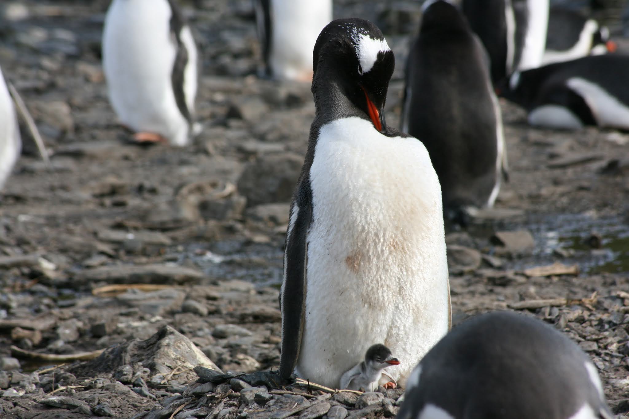
A Gentoo penguin with its newly hatched chick
After departing from Bird Island, we took a tour around Prince Olav Harbour. In this harbour stands one of South Georgia's main whaling bases built in 1916. Here the ship conducted it's 3-monthly mandatory life boat drills and then continued onto visit the 2-mile wide Possession Bay. An impressive ice-covered pass, 'Shackleton gap' glistened in the background. The latter is so-named after Shackleton and his party located this pass on a map during their transit across South Georgia in 1916.
Prince Olav Harbour- note the whaling station at the foothills of the mountain
An enormous colony of 1000's of king penguins in Possession Bay
Sailing around Possession Bay
Our next stop is the Falkland islands, 1,000 km South East.


Thank you for sharing such detailed content! I’ve been searching for the right itinerary, and the Georgia Tour Package From India looks like a fantastic option for travelers looking to experience a blend of history, nature, and adventure.
ReplyDelete